
Great Lakes Moment is a monthly column written by Great Lakes Now Contributor John Hartig. Publishing the author’s views and assertions does not represent endorsement by Great Lakes Now or Detroit Public Television.
Twenty-five years ago, several lower Detroit River islands and marshes were threatened by development. As part of a strategy to save these threatened ecosystems, local conservationists coined the term “Conservation Crescent” to better understand and raise awareness of the value and benefits of this crescent-shaped archipelago of islands and wetlands, which are critical to ecosystem health and provide many ecosystem services or benefits to humans.
The first time I heard of the Conservation Crescent was in 1998 when Dr. Bruce Jones and others from the Grosse Ile Nature and Land Conservancy called for saving Humbug Marsh, the last mile of natural shoreline on the U.S. mainland of the Detroit River, from development. Jones and his colleagues argued that “we need to save Humbug Marsh as part of the conservation crescent.” This was an elegant way of framing the lower Detroit River’s conservation challenges.
A few years earlier, in the early to mid-1990s, the 52-acre uninhabited Stony Island was on the market and threatened by development. This island has a rich history: it was used by the Potawatomi as a camp for hunting and fishing, served as a center of operations to construct the Livingstone Channel in the early 1900s, and became a base for dredging the shipping channels by Dunbar & Sullivan Dredging Company until it closed in 1987.
The Conservancy successfully advocated for a $750,000 Michigan Natural Resources Trust Fund to purchase this island in 1997 and preserve it as part of the Pointe Mouillee State Game Area. Then, from 2013 to 2018, Friends of the Detroit River and others championed an $8 million habitat restoration project through the Great Lakes Restoration Initiative. This restoration project created 3,600 linear feet of habitat shoals out in the river and provided 50 acres of backwater coastal wetland habitat. This provides important spawning and nursery ground habitats for fish like muskellunge, northern pike, pumpkinseed sunfish, largemouth bass, yellow perch, channel catfish, and bullhead, and nesting and feeding areas for migratory waterfowl. One of the amazing ecological features of Stony Island is that it supports the largest blue heron rookery in the area, with over 140 active nests.
Southeast of Stony Island in Canadian waters is Boblo Island, which was operated as an amusement park for nearly 100 years before closing in 1993. This 272-acre island is now a marina resort community, with a combination of condominiums and single-family houses connected by short roads on the island’s northern half. Nearly half of the southern end has been protected for conservation and outdoor recreation as the White Sands Conservation Area, which is managed by the Essex Region Conservation Authority.
Just west of Boblo Island and the Livingstone Shipping Channel is the 29-acre Sugar Island, which also operated as an amusement park from the late 1800s to the 1940s. It then became an uninhabited island threatened by development until it was purchased for the Detroit River International Wildlife Refuge in 2011. It is now undergoing an $18 million habitat restoration project championed by the Friends of the Detroit River and others, which will be completed in 2024. The west beach is open to the public for swimming, picnicking, and volleyball from dawn to dusk from Memorial Day to Labor Day.
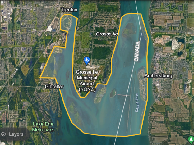
Moving around the lower end of the Conservation Crescent is the 158-acre Gibraltar Bay, a coastal embayment prized for its fishing and wildlife viewing. A 2010 fishery survey performed by the U.S. Fish and Wildlife Service found 34 species using the bay, most less than one-year-old. This means that the bay is an important fish nursery area.
Located in and along this bay is the refuge’s Gibraltar Bay Unit. From 1927 to 1969, it was part of Naval Air Station Grosse Ile. In the 1960s, it became part of the Public Health Service and then transferred to the U.S. Environmental Protection Agency in 1972. Over time, it was stewarded by Grosse Ile Nature and Land Conservancy, which included a $80,000 shoreline restoration in 2003-2005. It eventually transferred to the refuge in 2008 and consists of a prairie, wetlands, a pond, and trails open to the public year-round from dawn to dusk.
Adjacent to the Gibraltar Bay Unit is the 35-acre Airport Natural Area owned by Grosse Ile Township and stewarded by the Grosse Ile Nature and Land Conservancy. Debris left behind from Naval Air Station Grosse Ile has been removed, and trails and observation decks have been constructed so visitors can enjoy this natural area. It, too, is open to the public year-round from dawn to dusk. Both the Gibraltar Bay Unit and the Airport Natural Area have been identified by Detroit Bird Alliance (formerly Detroit Audubon) as part of a “birding hotspot.” It is also a great place to see Michigan’s symbol of clean water — the American lotus — in mid to late summer.
Located just east of Grosse Ile’s Gibraltar Bay is the 68-acre uninhabited Celeron Island. It is the southernmost island in the Detroit River and is uninhabited. It actually consists of two islands connected by a marsh in between. It, like Stony Island, is owned by the Michigan Department of Natural Resources and managed as part of the Pointe Mouillee State Game Area. In 2013-2020, the Friends of the Detroit River and other partners championed an $8.4 million habitat restoration project that improved spawning and nursery ground habitats for fishes and nesting and feeding areas for migratory waterfowl. It is also a favorite local swimming and picnicking area in the summer.
Just up the Trenton Channel of the Detroit River sits the 11-acre Calf Island. It is uninhabited, and its habitats consist of hardwood trees, emergent marshes, and a shallow bar — ideal habitats for wild celery, an important food for waterfowl. It, too, was threatened by development but was purchased by the U.S. Fish and Wildlife Service in 2002 to become part of the refuge.
Just north of Calf Island is the crown jewel of the refuge — Humbug Marsh — the last mile of natural shoreline on the U.S. mainland of the river. It has an old-growth forest with oak trees that are more than 300 years old — that were alive when Cadillac founded Detroit in 1701, an active bald eagle’s nest, and rare insect and plant species. This nursery of life is Michigan’s only Ramsar wetland of international importance. There are more than 2,400 Ramsar sites throughout the world, 41 in the United States, and only one in Michigan — Humbug Marsh.
Adjacent to Humbug Marsh is the Refuge Gateway with a green visitor center — gold Leadership in Energy and Environmental Design (LEED)-certified by the U.S. Green Building Council. It was a former automotive manufacturing plant site that was cleaned up and habitats restored as a model of sustainable redevelopment. In total, 16 acres of wetlands were restored, a creek was daylighted — taken out from underground in a pipe or culvert and exposed to sunlight, 25 acres of upland buffer habitat were rehabilitated, and invasive species were controlled on more than 50 acres of upland habitats, including removing invasive Phragmites along 2.5 miles of shoreline. This has resulted in merging the 44-acre Refuge Gateway with the 410-acre Humbug Marsh into one ecological unit and is helping create a truly exceptional outdoor recreational and conservation experience in the Detroit Metropolitan Area.
Located upriver from Humbug Marsh on the Trenton Channel is Wayne County’s 162-acre Elizabeth Park. It is the oldest county park in Michigan. In 2001, Wayne County Parks received a $1 million grant to remove a 1910 concrete breakwater and replace it with 600 feet of soft shoreline, including underwater fish habitat and two oxbow islands that provide nursery habitat for fish.
In 2017 and 2018, Wayne County Parks received additional funding for a connector greenway, which will provide a missing trail link between downtown Trenton and the Refuge Gateway. As part of this project, the Elizabeth Park canal shoreline was rehabilitated using soft shoreline techniques, including stabilizing the shoreline and minimizing erosion, enhancing habitat for fish and wildlife, and removing invasive plant species. This project also improved public access for fishing, canoeing, and kayaking.
It should also be noted that Ducks Unlimited has identified the Detroit Metropolitan Area, especially the lower Detroit River with its Conservation Crescent and Pointe Mouillee State Game Area, as one of the top ten metropolitan waterfowl hunting areas in the United States. Areas open to waterfowl hunting during fall and winter include Stony Island, Celeron Island, Humbug Marsh and Island, Calf Island, and Sugar Island.
Detroit River shares the distinction with Lake Erie of being the “Walleye Capital of the World.” An estimated 10 million walleye ascent the Detroit River from Lake Erie each spring to spawn, creating an internationally renowned sport fishery. International fishing tournaments offer more than $500,000 in prize money.
Kayaking has also grown substantially through the Detroit Heritage River Water Trail. Downriver Linked Greenways has even designed a water trail segment as the Conservation Crescent Loop.
Any one or two of the above projects would be considered significant for an area well known as the industrial heartland and Rust Belt. However, when viewed in total, they represent a truly amazing conservation success story of saving the Conservation Crescent.
“I am grateful to the citizens, organizations, and politicians whose foresight and determination preserved the Conservation Crescent for generations to come,” said Paul Gloor, president of Grosse Ile Nature and Land Conservancy. “It stands as a shining example of what can be achieved when individuals take a stand for what they believe in. It is a powerful reminder that each of us can make a difference.”
Maybe it is time to re-energize the concept of the Conservation Crescent. Just like 25 years ago, it could be used as a rallying cry or lever to accelerate the cleanup of remaining contaminated sediments and brownfields that are stopping Downriver from shaking its Rust Belt image and stymieing further progress. Perhaps this concept could become part of a marketing campaign – Live, Work, and Play in the Heart of the Conservation Crescent!
John Hartig is a board member at the Detroit Riverfront Conservancy. He serves as a Visiting Scholar at the University of Windsor’s Great Lakes Institute for Environmental Research and has written numerous books and publications on the environment and the Great Lakes. Hartig also helped create the Detroit River International Wildlife Refuge, where he worked for 14 years as the refuge manager.
Catch more news at Great Lakes Now:
Great Lakes Moment: Gordie Howe International Bridge becomes part of binational trail system
Great Lakes Moment: Lest we forget – A history of Detroit River oil pollution
Featured image: Lower Detroit River and the Conservation Crescent. (credit: Google Earth)
