
By Darby Hinkley, The Alpena News
This article is part of a collaboration between The Alpena News and Great Lakes Now at Detroit Public Television to bring audiences stories about the Great Lakes, especially Lake Huron and its watershed.
ROGERS CITY — BEN gets around. From coast to coast in the U.S., to American Samoa, and back to Lake Huron, the autonomous surface vessel (ASV) is in Rogers City this month for lake floor mapping.
This is BEN’s second trip to Rogers City. The first one was in 2019, and BEN would have been back in 2020 if not for the COVID-19 pandemic.
BEN stands for bathymetric explorer and navigator, said Dwight Coleman, expedition leader for the Ocean Exploration Trust.
“It’s equipped with multibeam sonar devices for scanning the lakebed acoustically and measuring, with really high accuracy and precision, what the depths of the lakebed are,” Coleman said on Tuesday morning at the Rogers City Marina. “We can use it to look for shipwrecks and we can use it to look for geological and biological targets.”
While Coleman was talking, another crew member was getting in and out of the ASV.
“KG (Fairbarn) is one of the engineers in charge of working on the vehicle, so he has to climb down into that hatch periodically to turn it on and adjust some settings,” Coleman explained.
He added that it goes out by itself, and they control it remotely from inside the research trailer.
“It is uncrewed, as we call it,” Coleman said. “The trailer is what we call the ASV Control. You’ll see the antennas on it. So, the antennas here connect to the antennas on the vehicle, wirelessly.”
It’s definitely not a big remote-controlled toy, Coleman assured.
“It’s a pretty serious operation,” Coleman said. “We have to collect good … scientific information about the lake floor here, because, in order to interpret archaeological sites or geological sites, we need to understand what the bathymetry is,” Coleman said. “The bathymetry is the shape of the lake floor.”
He said most of BEN’s expeditions have been in the ocean.
Contrary to the masculine-sounding name, BEN’s pronoun is “she/her.” Coleman said vessels are called “she” as a tradition.
“BEN is out of the University of New Hampshire,” Coleman said. “It’s part of an organization called … the Center for Coastal and Ocean Mapping, and it was a customized vehicle, but purchased from a vendor, ASV.”

He said the UNH Research Team has modified BEN.
“They’ve modified it, and added a lot of capabilities to it, including advanced telecommunications, and advanced systems for mapping, and understanding the data, and managing the data that it collects,” Coleman said.
BEN travels a lot.
“We send it off on all sorts of different projects, so it’s been in the Pacific Ocean quite a few times, it’s been up to the Arctic, off the Alaska coast, it’s been to the American Samoa island — there’s another National Marine Sanctuary there,” Coleman said. “It’s been to an island called Nikumaroro, and it took part in an expedition to search for the remains of Amelia Earhart’s plane. We didn’t actually find it, but (BEN) aided in the search for that.”
Coleman explained the partnership between his organization (OET), NOAA and UNH.
“We have the partnership with the sanctuary program,” he said. “And we brought in the UNH team as a partner on the project.”
He explained why it’s important to map detailed information about the lake floor.
“That helps us understand the context of where targets might be that are of interest, for management purposes, for exploration purposes,” Coleman said. “That includes shipwrecks, but it also includes geological formations and any sites that are important for biological studies.”
One example is fish habitat, he added.
“So, understanding … the topography of the lake bed — the shape and the nature of it — that’s important information for managing resources,” he added. “Biological resources, geological resources, and archaeological resources.”
The 12-person crew started operations in Rogers City on Monday, and will be conducting research there until June 23, with the goal of mapping 100 kilometers of lake floor.
“We work about 12-hour days,” Coleman said, from 7:30 a.m. until 7:30 p.m. “It takes about an hour to get out to the sites that we’re surveying, and we collect data for about a good eight hours a day … this is all brand-new exploratory information. We’re targeting the shipping lanes … where there’s likely to be shipwreck targets that haven’t been found yet.”

According to Stephanie Gandulla, maritime archaeologist with NOAA’s Thunder Bay National Marine Sanctuary, 99 shipwrecks have been identified, but about 100 more unidentified shipwrecks are estimated to be out in the sanctuary.
“This is all about opportunities to learn and to work together as teams in partnership,” Coleman said. “We’re a diverse group of people, mostly with engineering and science backgrounds, and operating technology. There’s a lot of training happening, too. NOAA operates the Office of Coast Survey, which is responsible for all the nautical charts, and the charts of the lake, for navigational purposes.”
He said they are training people from the Office of Coast Survey to learn how to use ASV technology.
“Instead of using ships that burn lots of fuel, and require lots of crew, and are very expensive to operate, these vessels are more efficient and more economical, and using more advanced technology,” Coleman added. “We’re training people to get the skills they need to do this sort of thing, and we think that’s really important for the future.”
TBNMS Maritime Archaeologist Gandulla is supporting the project as the research coordinator and the operator of the NOAA 3011 30-foot vessel, which goes out and follows BEN around.
“We accompany BEN to deploy scientific instruments to measure the temperature of the water,” Gandulla said. “We deploy this thing all the way the the bottom, and it’s, like, 200 feet out there … the scientists are then able to apply that to the data that (BEN) is collecting.”
Coleman added that BEN is worth several hundred thousand dollars, and increasing in value as more sonar, telecommunication, and data server devices are added to it.
“Even though it’s autonomous, obviously it takes a lot of engineering and computer programming and mapping software, so that’s why this whole team is here,” Gandulla said.
Andy McLeod, engineer with the UNH Center for Coastal and Ocean Mapping, noted that the vessel is named BEN for two reasons. It’s the aforementioned acronym, but it is also in honor of Ben Smith, their ship captain who passed away in 2016.
“BEN is a robotic vessel that we’ve developed in collaboration with all kinds of other folks,” said Val Schmidt, research engineer at the Center for Coastal and Ocean Mapping at the University of New Hampshire, where he also leads the robotics team.
He said funding for BEN was provided by NOAA’s Office of Coast Survey.
“BEN has state-of-the-art sea floor mapping systems, sonar systems and navigation systems, and we’re working on ways to make sea floor survey from robotic vessels safe and practical so that we can increase the efficiency and the safety of those operations for sailors at sea, doing all the hard work of making nautical charts for safety,” Schmidt said.
BEN runs on a three-cylinder Yanmar diesel engine, very similar to a sailboat, according to KG Fairbarn, autonomous systems engineer with UNH.
The engine can run for 18 hours, he said, and it has, on an Alaska expedition.
Schmidt explained what they are hoping to find.
“This is really a multidisciplinary effort,” Schmidt noted. “Of course, we’re hosted by the National Marine Sanctuary, and they’re all about underwater archaeology, so we’re looking for shipwrecks. But, there are all kinds of other uses for sea floor mapping data.”
Geologists are interested in the sinkholes in the middle of the lake, he said.
“Fisheries folks are interested in fish habitat,” he continued.
He added that paleontologists are interested in the glaciology of the region.
“When the glaciers were here, how that shaped the bottom of the lakebeds,” Schmidt explained.
He then noted his specific interests.
“But then, for my own team, we’re sort of nerdy robotics engineers folks, and we’re all interested in ways to detect other vessels around us, have constant telemetry links when BEN is way out on the horizon,” Schmidt said.
He added that BEN has six cameras all facing in different directions.
“We’re running neural networks on board to detect things in real time and classify them, like ‘there’s a boat’ and ‘there’s a lighthouse,’” he said. “There’s radar on there that will also detect other boats so we can keep things safe.”
He noted that the mapping is being done in the middle of a busy shipping lane with big freighters going by, so staying out of their way is a huge priority.
“It’s a great opportunity for us to both collect data for the sanctuary and forward their mission, but also field test and actually do all of the stuff that we’ve been tinkering with in the lab during COVID,” Schmidt said. “We’re super excited to be here.”
Catch more news on Great Lakes Now:
Ship-top vaccinations help keep freighters hauling
Great Lakes Sanctuaries: Two more National Marine Sanctuaries in the region see the finish line
Shipwreck Life: How fish and other aquatic species utilize Great Lakes shipwrecks
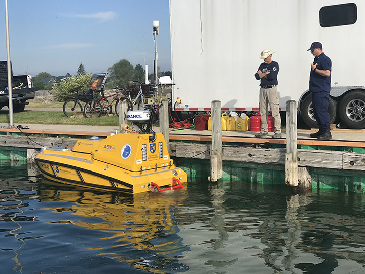
Featured image: BEN, an expensive piece of high-tech underwater research equipment, sits in the water at the Rogers City Marina on Tuesday morning, waiting to go miles out into the Thunder Bay National Marine Sanctuary to map the lake floor. Standing near BEN (bathymetric explorer and navigator) are Andy McLeod, engineer with the University of New Hampshire Center for Coastal and Ocean Mapping, and Lt. Jr. Grade Michael Card with the National Oceanic and Atmospheric Administration (NOAA) Office of Coast Survey. (Photo Credit: Darby Hinkley/The Alpena News)
